Introduction to the challenge
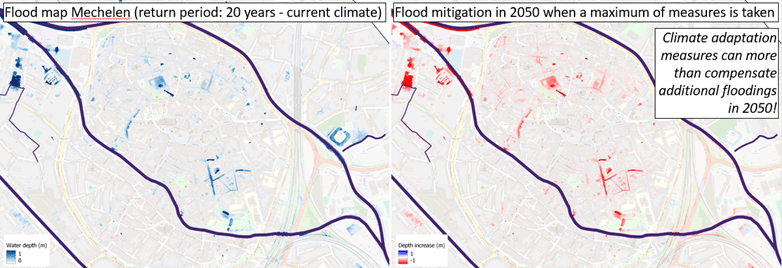
The Flemish Environment Agency (VMM) wants to offer an interactive tool to assess the climate adaptation potential in general and the effectiveness of specific climate adaptation measures on a project scale. And this for the whole of Flanders, an area of no less than 13,500 km2. Flood modelling is needed to assess the extent to which adaptation measures can reduce floods. To do this even at street level, the urban drainage system should be part of the model: such a holistic modelling approach is unprecedented on a Flanders-wide level.
The challenge was therefore to develop flood maps over a very large area and with a high level of detail within a limited time and budget and using the readily available data. The client also requests a significant number of scenarios. The majority of these scenarios are climate adaptation scenarios, which also require new tools as part of the modeling procedure.
The time limitation is an important constraint: classical modelling software require too much calculation time and massive amounts of extra data. Considering the area to be modelled and the number of scenarios, the use of classical software would make the budget prohibitive.
Our approach and solution
Masterplanner is applied to simulate (pluvial) flooding across Flanders for the current climate and various climate adaptation scenarios


- Apply holistic modelling (surface, river and sewer runoff, and their interactions)
- Efficiently set up models in limited time based on readily available GIS data and using a largely automated model building approach
- Model accurately by applying a subgrid approach on a relatively coarse computational raster
- Model source control measures
These aspects make the software very suited for the challenge posed by VMM in terms of timing and model requirements. The software even offers the possibility to model source control measures from raster information on the most likely measures for each location. This property allows to run the requested source control scenarios automatically.
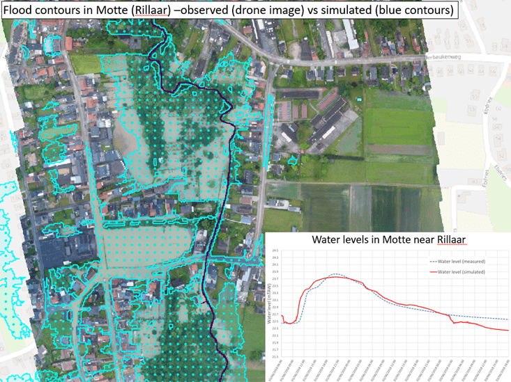
It was therefore decided to apply Masterplanner to simulate pluvial flooding for the whole area of Flanders (13500 km2). This decision also raised the challenge for a thorough model validation study. In this study, recent floods were modelled in different Flemish catchments using the rainfall radar data of these events. The resulting water level timeseries and flood extents could be compared to data from several measurement stations across these catchments and drone images of the flood extents during these events.
The validation proved the Masterplanner results to be representable for the actual flood depths and extents. These results convinced VMM that Flood4Cast Masterplanner was the right tool to simulate the effect of the climate adaptation scenarios on pluvial flooding across Flanders.
The benefits
10 times faster. Ideal for flood map generation and climate adaptive scenario planning for large areas
Masterplanner is an accurate modelling software to model flooding and investigate the effects of source control measures! The efficient model setup allows to build models up to 10 times faster.
- Holistic models for the whole of Flanders were set up in roughly ten months – this is an estimated 10 times quicker than other software for comparable holistic models
- Validation of the Masterplanner results for historic events proves its accuracy
- Masterplanner has a source control module that allows to assess the effect of source control measures on generic scale and project scale
- Low calculation times allow the simulation of a large number of scenarios
This makes Masterplanner the unique and ideal solution for flood map generation in large areas and rapidly perform impact assessment of climate adaptation scenarios!
Reference
Craninx, M., Hilgersom, K., Dams, J., Vaes, G., Danckaert, T., Bronders, J. (2021), Flood4castRTF: A Real-Time Urban Flood Forecasting Model. Sustainability, 13, 5651.
Deel deze pagina
![[:swvar:ufile:1:description:]](/swfiles/files/logo_hydroscan_rgb.png?nc=1744884622)
